Lopinot
by Ronald C. Emrit
 Lopinot is located north of Arouca on the southern slopes of the northern mountain range. It was founded in 1806 by Count Lopinot (Charles Joseph Comte Loppinot de la Fresilliere) who was granted 478 acres of land by the King of England. Count Lopinot established a cocoa estate on the land and called it La Reconnaissance. The name Lopinot has its origins in the French village of Belforde which is situated close to the border with Switzerland. Lopinot is located north of Arouca on the southern slopes of the northern mountain range. It was founded in 1806 by Count Lopinot (Charles Joseph Comte Loppinot de la Fresilliere) who was granted 478 acres of land by the King of England. Count Lopinot established a cocoa estate on the land and called it La Reconnaissance. The name Lopinot has its origins in the French village of Belforde which is situated close to the border with Switzerland.
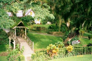
Count Lopinot left France in 1781 for the French territory of Louisiana (which later became part of the USA) where he went on to serve in the military. He moved to Haiti where he fought with British troops against the revolutionary Toussaint L'Overture in 1789. He fled with his family to Jamaica where he petitioned the King of England for compensation for his losses in Haiti while fighting with the British military. With his wife, children, and 100 slaves, Count Lopinot was transported in 1800 by the the British Government to Trinidad where a parcel of land in Tacarigua was sold to him by the military governor, Lieutenant General Thomas Picton. He was able to make payments for his land by growing sugar cane until 1805, when the European demand for sugar declined and he was forced to give up his land. In his quest for other land, he settled in the Northern Range and received a land grant from the King of England for what was later called Lopinot. Count Lopinot died in 1819 and, in 2003, his tomb was still prominently visible in the Lopinot Village cemetery. Lopinot can be accessed by the Lopinot Road which runs north of the Eastern Main Road. Its economy is driven by ecotourism as many visitors come to the area to explore the Lopinot Caves and the Lopinot Complex (see photo above). Surrey Village is one of the communities of Lopinot. |

Replies